As a means of emergency response after a flooding event or inland inundation, flood mapping helps to estimate the extent of the flood on a large scale. It is a basis of coordinating appropriate damage assessment activities, and providing relief to the victims. This blog explains an approach of community flood response by community mapping methods and rapid assessment to determine extent and damage.
In responding to heavy rainfall on March, 3rd, 2019, that resulted in heavy flooding in some wards of Dar es Salaam Tanzania, the Ramani Huria team decided to conduct field mapping to engage affected communities with the aim of conducting a rapid assessment and producing impact maps. In these wards, community leaders identified a total of 1907 flooded houses. The survey was conducted in three of the most affected wards as reported by local newspaper (Mwananchi). It appears that the impact was severe on these wards due to multiple river channels meeting at these places causing massive outflows to the residential areas as well as inadequate drainage and blockage due to improper dumping.
Ramani Huria visited the affected wards and worked closely with community leaders to conduct rapid survey and assessment of impacts by:
- Conducting meetings with community leaders and identifying the affected areas on printed A1 maps of the specific places
- Field visits to physically assess the situation, taking photos and geo-points in some of the affected areas using OpenDataKit Collect, a mobile application that is used for field survey.
The maps used to conduct this assessment are the risk identification maps that were produced by RH team during the 2018 July summer industrial training. As we reported earlier, the maps were produced for the aim of developing ward disaster management plans with the overarching goal of creating a resilient city.
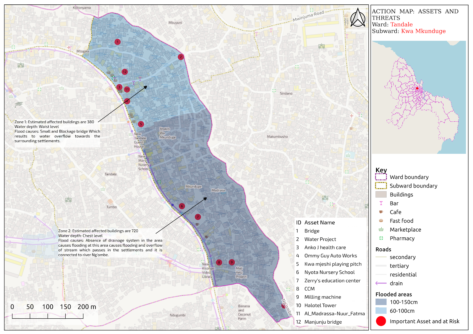
A map showing flooded areas in Tandale Ward, Mkunduge subward was all flooded
More maps created can be found here
The impact of the foods included loss of properties, destruction of houses, students missing schools for two days because the roads were flooded, and their school books/items were destroyed by the heavy flood. Although there were no casualties, the impact affected communities significantly. Other people evacuated to nearby places that were safe at the moment, but in all these wards there were no specified evacuation centers where citizens can run to when it floods. This calls for government, disaster responders, humanitarian organizations, NGO’s and the community in general to “think” and plan how they can make sure there are safe places to stay when it floods.

Among flooded houses in Hananasif ward, Dar es salaam. The marks in the walls can explain the severity of flood
The objective of this practice was to identify the extent of flooding in the most affected wards as well as the affected infrastructure such as roads and settlements and impaired areas of interest, for example schools and hospitals. The Ramani Huria team will be actively disseminating this report within the affected communities, and working to facilitate dialogue with PO-RALG, the Red Cross, NGOs, World Bank, and other stakeholders to make use of the information for future mitigation efforts, rescue and relief activities in affected areas.
In recent years experts in disaster responses are hopeful for the future of satellite and mapping technology in responding to disaster. If a flood response map is well developed, what you really have here is a map of the future. It can help in predicting the impact of future flood events and help in mitigation measures too.
Simply by recording data from presently flooded areas can be useful when identifying areas at risk of future flooding. With climate change well underway, people are increasingly interested in predicting the ways that flooding will worsen.
Digital data such flood data needs to be (easily) accessible and downloadable data for disaster responders to act quickly and save lives. Thanks to local people, local devices (mobile phones) and open knowledge (free software like OpenDataKit and the skills to use it), they say information should become even more accessible in the years to come. Flood data also needs to be in online interactive maps that can be integrated with mobile applications for easy access. The Ramani Huria team will be willing to provide such data so as to help more people and develop effective flood mitigation measures.